Where the weather is: Destin — Hurricane Warning · Pensacola — Storm Surge Warning · Atlanta — High Wind Warning · Birmingham — Tropical Storm Warning · San Diego — Tropical Storm Watch · Washington — rain median 1.1 inWhere the weather is: Destin — Hurricane Warning · Pensacola — Storm Surge Warning · Atlanta — High Wind Warning · Birmingham — Tropical Storm Warning · San Diego — Tropical Storm Watch · Washington — rain median 1.1 inWhere the weather is: Destin — Hurricane Warning · Pensacola — Storm Surge Warning · Atlanta — High Wind Warning · Birmingham — Tropical Storm Warning · San Diego — Tropical Storm Watch · Washington — rain median 1.1 inWhere the weather is: Destin — Hurricane Warning · Pensacola — Storm Surge Warning · Atlanta — High Wind Warning · Birmingham — Tropical Storm Warning · San Diego — Tropical Storm Watch · Washington — rain median 1.1 inWhere the weather is: Destin — Hurricane Warning · Pensacola — Storm Surge Warning · Atlanta — High Wind Warning · Birmingham — Tropical Storm Warning · San Diego — Tropical Storm Watch · Washington — rain median 1.1 inWhere the weather is: Destin — Hurricane Warning · Pensacola — Storm Surge Warning · Atlanta — High Wind Warning · Birmingham — Tropical Storm Warning · San Diego — Tropical Storm Watch · Washington — rain median 1.1 in
Hurricane Isaias comes ashore on the north central Gulf Coast this evening, and gusts in New Orleans peak around 8 AM at a median 41 mph, tropical storm force, with the strongest runs reaching 68. Eastern Orleans Parish sits under a Tropical Storm Warning, and the Coastal Flood Advisory holds through 7 PM Saturday.
The best shot at showers comes tonight at 42%, and the steadiest rain stays east of Interstate 59, with the area west of I-55 possibly staying dry. The lower odds reflect where the rain bands fall, not a weaker storm, and the coastal flooding concern remains in place.
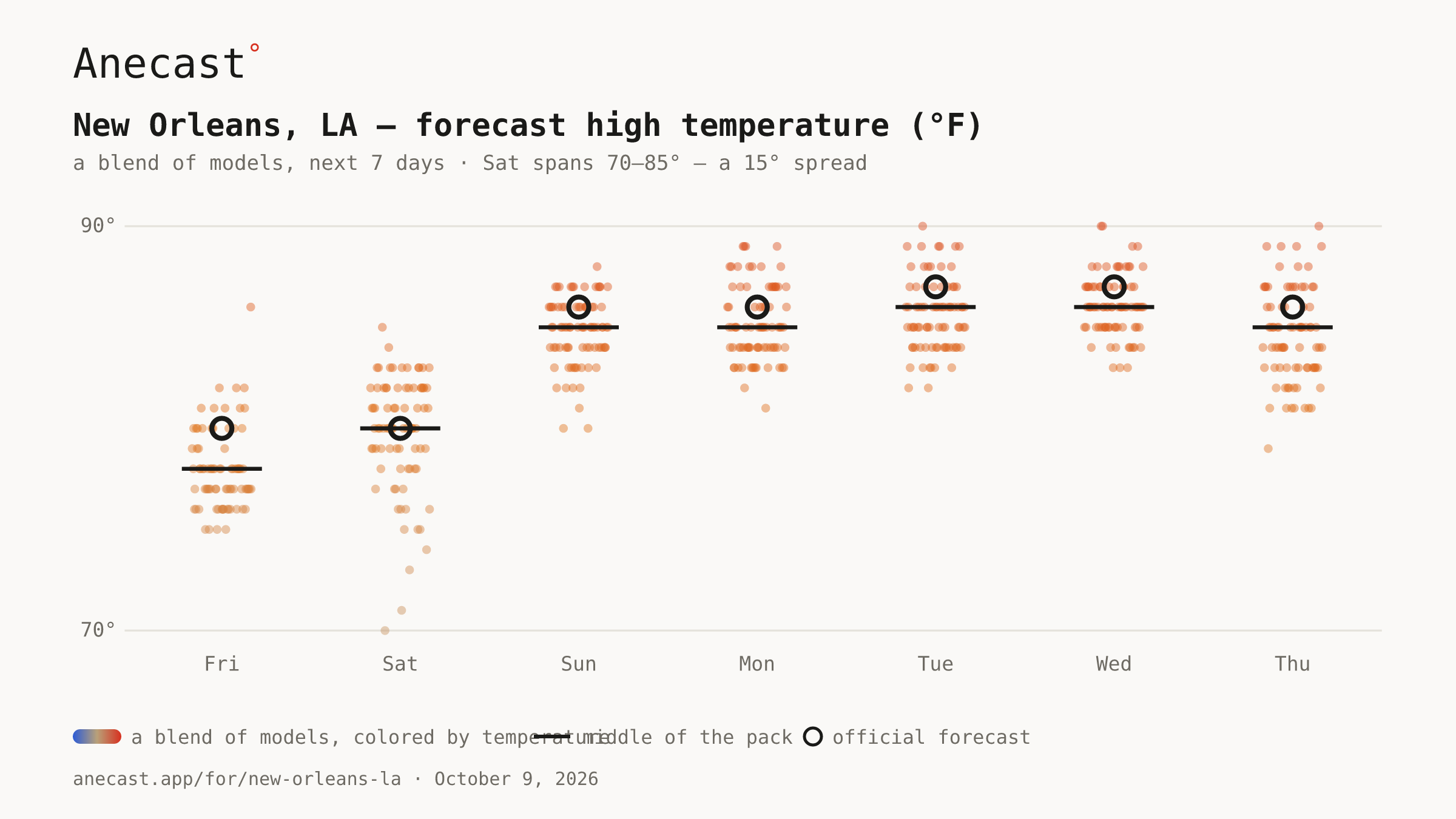
Saturday is split from 70 to 85 across the runs, with the outcome hinging on how quickly Isaias draws cooler, drier air behind it as it races off; lows by morning could reach 60 to 65 in spots. The middle of the pack lands near 80.
spread · saturday
Forecast high temperature (°F) · next 7 days · a blend of models
Next week, high pressure settles directly over the area, keeping skies mostly clear and temperatures as much as 10 degrees above normal. Several runs reach 90 by Tuesday and Wednesday.