Where the weather is: Great Falls — 5 straight days above normal (avg +11.2°) · Denver — 4 straight days above normal (avg +10.3°) · Fort Collins — 4 straight days above normal (avg +10.8°) · Los Angeles — 7 straight days above normal (avg +12.6°) · New Orleans — 4 straight days below normal (avg -5°) · Pensacola — 4 straight days below normal (avg -6.7°)
Weather worth knowing

Foxfield, CO

Wednesday, October 21

75°mostly clear

Your day

Cool start warming fast, warm and partly sunny this afternoon near 74°, then a warm, gray evening; a light layer early is all you need.

MORNING48–63°MIDDAY66–73°AFTERNOON72–74°EVENING61–69°↑ 7:16 AM↓ 6:11 PMNOWSO FAR · OBSERVED
MORNING48–63°MIDDAY66–73°AFT'NOON72–74°EVENING61–69°↑ 7:16 AM↓ 6:11 PMNOWSO FAR · OBSERVED
Morning
cool, warming fast
light layer early
Midday
warm and sunny
Afternoon
warm and partly sunny
Evening
warm and gray

We've cut Sunday's high from 60° to 53°

We've trimmed Sunday's high from 60° to 53° as a leftover low from the departing trough closes off over the Southwest and pushes deeper moisture and cloud into eastern Colorado. NWS raised Sunday's rain chance from 11% to 31%, a real shot at meaningful precipitation for a dry month.

revision · cooldown

Know when Foxfield's forecast changes: one email every morning. Get the morning edition

The week ahead

Forecast changes since this morning

Monday 55°→52°

Changed since yesterday

We've lowered Sunday's high from 60° to 53° since yesterday — We've cut Sunday's high from 60° to 53°

Sunday 60°→53° Sunday rain 11%→31% Monday 61°→52° Monday rain 2%→17%

Next five days · the Anecast forecast

WedThuFriSatSun
High73°73°75°55°53°
Low53°55°44°38°37°
Precip3%11%5%55%31%

Highs tinted vs today's normal (65°): 8° below 8° above

The week, as the models see it

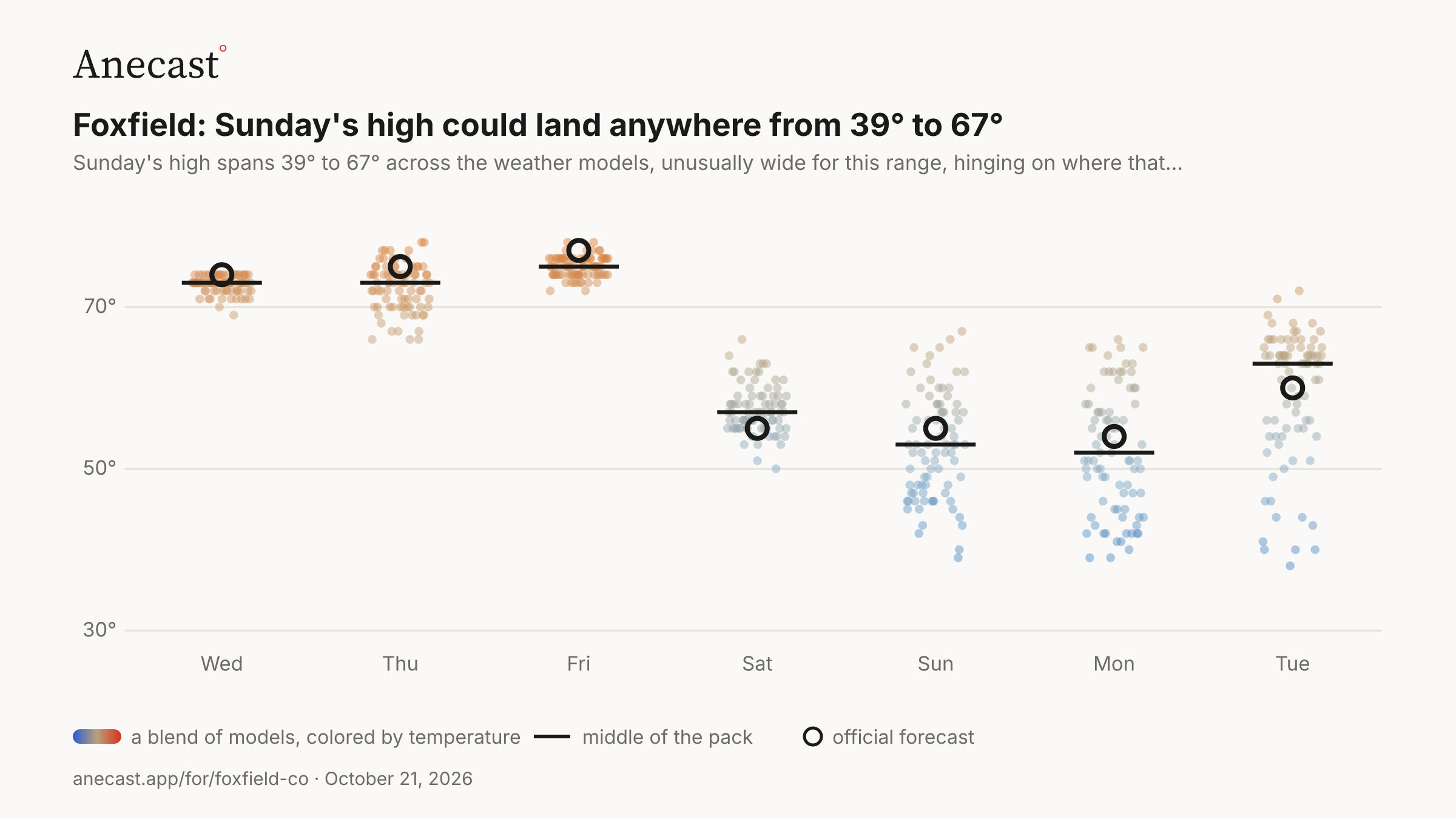
Sunday's high could land anywhere from 39° to 67° — the models span 39–67° on Sun, most near 53°.

Forecast high temperature (°F) · next 7 days · a blend of models
PNG ↓
30°50°70°WedThuFriSatSunMonTue

82 model runs, colored by temperature  ·  middle of the pack  ·  NWS forecast

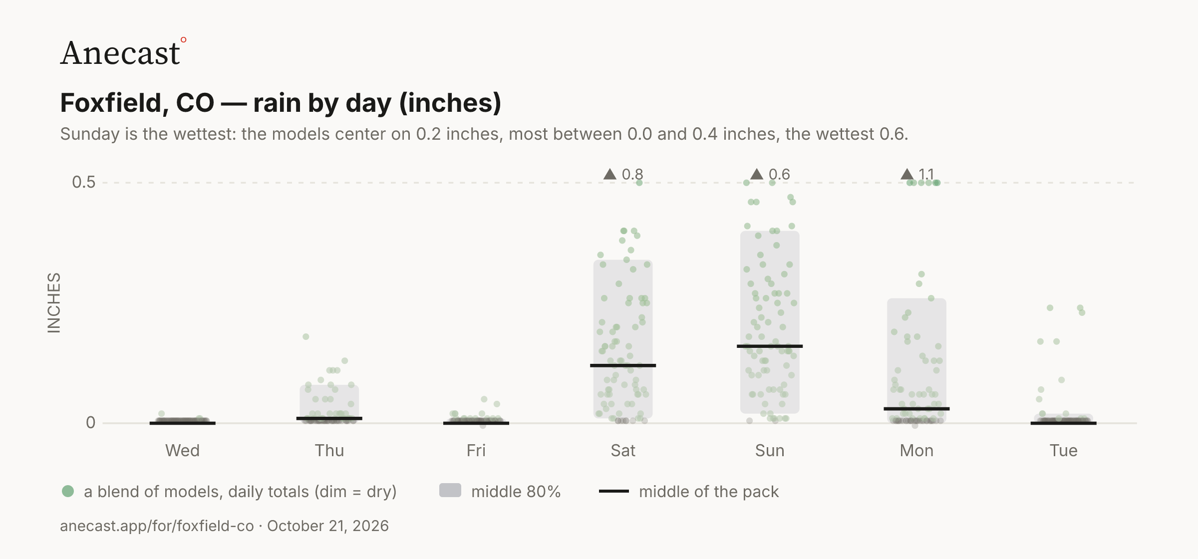
Sunday is the wettest: the models center on 0.2 inches, most between 0.0 and 0.4 inches, the wettest 0.6.

Rain by day (inches) · next 7 days · a blend of models
PNG ↓
0.50WedThuFriSatSunMonTue▲ 0.8▲ 0.6▲ 1.1INCHES

82 model runs, daily totals (dim = dry)  ·  middle 80%  ·  middle of the pack

Today in station history (7 stats, records back decades)
StatValueYear(s)
record high for day 82.9 2003
record low for day 19.9 1996
average high for day 65 —
average low for day 37.3 —
warmest low for day 54 1947
coldest high for day 28.9 1984
largest temp swing for day 44.1 1987

Also worth knowing

Tuesday ran 3° cooler than forecast

Yesterday came in 3 degrees cooler than forecast: we called for 71° and Denver - Centennial read 68°, colder than all but about 5% of Monday's weather models. The official airport gauge hit 73°, a reminder of how much the metro split.

receipt · verification

Today should make five straight warm days

Foxfield had run above normal for four straight days through Tuesday, averaging 10 degrees warm, and today's high near 74° should stretch it to five. It stays dry too, with no measurable rain on at least five straight days and October 0.52 inches short of normal.

streak · dry

Sunday's high could land anywhere from 39° to 67°

Sunday's high spans 39° to 67° across the weather models, unusually wide for this range, hinging on where that closed low tracks before it shears out. We lean cool at 53° because the European and AI guidance run 10 to 15 degrees colder than the warm GFS.

uncertainty · weekend

Afternoon edition, 2026-10-21 · grounded in station records · tomorrow morning: what today's forecast said, next to what happened.

Yesterday's receipt · Tuesday

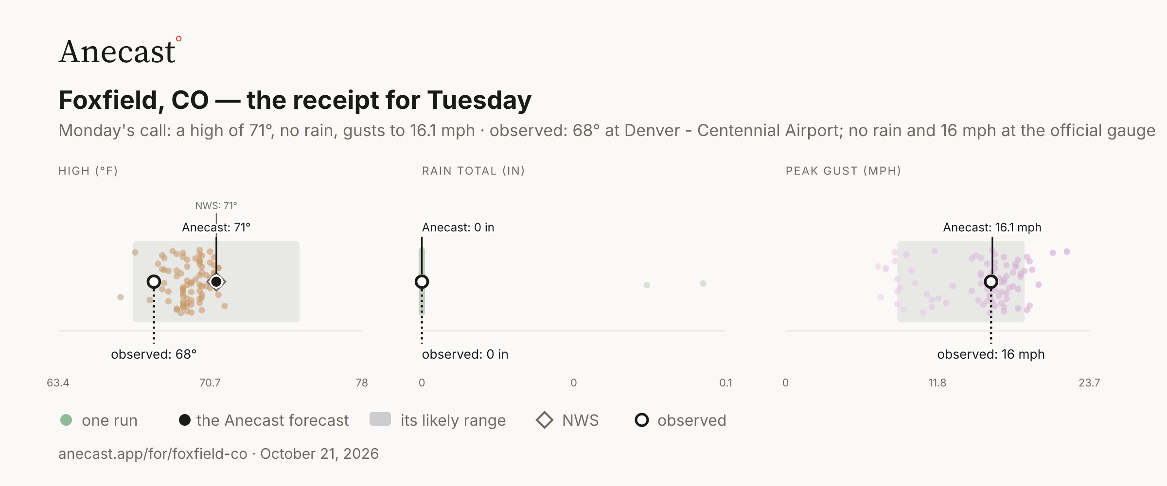
What Monday's forecast said for Tuesday · what was observed
PNG ↓
HIGH (°F)NWS: 71°Anecast: 71°observed: 68°63.470.778
RAIN TOTAL (IN)Anecast: 0 inobserved: 0 in000.1
PEAK GUST (MPH)Anecast: 16.1 mphobserved: 16 mph011.823.7

Anecast forecast  ·  likely range  ·  dots = 82 runs, Monday  ·  ◇ NWS  ·  observed, Tuesday

Monday's call for Tuesday: a high of 71°, no rain, gusts to 16.1 mph. Observed: 68° at Denver - Centennial Airport; no rain and 16 mph at the official gauge.

Around Foxfield · Tuesday

Denver - Centennial, 5.2 miles away and the station that grades Foxfield's forecast, read a high of 68°; the official gauge at Denver hit 73°, 5° hotter.

DOUGLASARAPAHOEJEFFERSONELBERT Foxfield HIGH (°F)64°73°official climate stationgrades the forecastDenver - Centennial Airport · grades the forecast · 5.2 mi · high 68° · low 45° · rain not reported 68°Denver - CentennialBuckley Space Force Base · 8.4 mi · high 71° · low 48° · rain not reported 71°BuckleyColorado Air and Space Port Airport · 17.8 mi · high 68° · low 46° · rain not reported 68°Front RangeDenver, Denver International Airport · the official climate station · 18.4 mi · high 73° · low 52° · rain not reported 73°DenverElbert Mountain - Monument Pass · 26.3 mi · high 64° · low 41° · rain not reported 64°Elbert Mountain - Monument PassBroomfield / Jeffco · 28.1 mi · high 72° · low 48° · rain not reported 72°Broomfield / JeffcoErie Municipal Airport · 32.8 mi · high 73° · low 38° · rain not reported 73°ErieLOW (°F)38°52°official climate stationgrades the forecastDenver - Centennial Airport · grades the forecast · 5.2 mi · high 68° · low 45° · rain not reported 45°Denver - CentennialBuckley Space Force Base · 8.4 mi · high 71° · low 48° · rain not reported 48°BuckleyColorado Air and Space Port Airport · 17.8 mi · high 68° · low 46° · rain not reported 46°Front RangeDenver, Denver International Airport · the official climate station · 18.4 mi · high 73° · low 52° · rain not reported 52°DenverElbert Mountain - Monument Pass · 26.3 mi · high 64° · low 41° · rain not reported 41°Elbert Mountain - Monument PassBroomfield / Jeffco · 28.1 mi · high 72° · low 48° · rain not reported 48°Broomfield / JeffcoErie Municipal Airport · 32.8 mi · high 73° · low 38° · rain not reported 38°Erie
The stations
StationMilesHighUsual gapRain (at least)
Denver - Centennial Airport · grades the forecast5.268°-2°—
Buckley Space Force Base8.471°0°—
Colorado Air and Space Port Airport17.868°0°—
Denver · official gauge18.473°0°—
Elbert Mountain - Monument Pass26.364°-7°—
Broomfield / Jeffco28.172°0°—
Erie Municipal Airport32.873°+1°—

Observed at NOAA stations near the gauge: the National Weather Service's airports and mesonets, and on the coast NOAA's tide stations. A station's rain is "at least" what it reported. Foxfield's temperature forecast is graded at Denver - Centennial Airport, the nearest station with a full day of readings; rain at the official gauge.

Keeping score

The scorecard · this week›

M
T
W
T
F
S
S

2 of 2 days on target

How each day was scored
ObservedAnecastNWS
forecastmissforecastmiss
Mon high 70° ✓ 68° −2° 68°−2°
rain 0.0 in ✓ 0.0 in in range 4%% only
Tue high 68° ✓ 71° +3° 71°+3°
rain 0.0 in ✓ 0.0 in in range 4%% only

Temperatures observed at Denver - Centennial Airport, 5.2 miles from Foxfield; rain at the official gauge (DEN), the nearest one. Every forecast is from the day before. A ✓ means the high landed inside the Anecast range, or the rain inside the models' band; gusts are shown but not graded.

Recent days

4 straight days above normal through Tuesday, Oct 20, since Saturday, Oct 17, averaging +10.3° · the last 5 days averaged +6.6° against normal · at least 5 straight days with no measurable rain (the tape begins Friday, Oct 16; the streak may be longer) · October so far: 0.17 inches of rain, 0.52 below normal · since Jan 1: 9.64 inches of rain, 3.55 below normal

Know when Foxfield's forecast changes

One email every morning: what changed overnight, what's unusual, and what yesterday's forecast got right or wrong. Free. Unsubscribe anytime.

Missing your city?

A request is how a place gets on the roster; the forecast tools already answer for anywhere in the US.