Where the weather is: Great Falls — 5 straight days above normal (avg +11.2°) · Denver — 4 straight days above normal (avg +10.3°) · Fort Collins — 4 straight days above normal (avg +10.8°) · Foxfield — 4 straight days above normal (avg +10.3°) · Los Angeles — 7 straight days above normal (avg +12.6°) · New Orleans — 4 straight days below normal (avg -5°)
Weather worth knowing

Rehoboth Beach, DE

Wednesday, October 21

63°clear

Your day

A cool, breezy start turned mild and partly sunny, going gray this evening; tonight's high tide could flood the most vulnerable coastal and bayside roads, with some closures possible until 10 PM.

MORNING54–55°MIDDAY57–61°AFTERNOON61–63°EVENING57–60°↑ 7:16 AM↓ 6:13 PMNOWSO FAR · OBSERVED
MORNING54–55°MIDDAY57–61°AFT'NOON61–63°EVENING57–60°↑ 7:16 AM↓ 6:13 PMNOWSO FAR · OBSERVED
Morning
cool and breezy
Midday
mild and sunny
Afternoon
mild and partly sunny
Evening
mild and gray

Alerts · National Weather Service

Coastal Flood Advisoryuntil Wed 10 PM

Evening high tide brings peak flooding through 10 PM

This evening's high tide is the peak of the week's coastal flooding in Rehoboth Beach, with minor flooding on the most vulnerable coastal and bayside roads and moderate flooding possible in some back bays; the advisory runs until 10 PM. Waves of 10 feet or more just offshore will keep chewing at the beaches around high tide, and coastal gusts of 30 to 40 mph linger into the evening.

coastal flood · surf · wind

Know when Rehoboth Beach's forecast changes: one email every morning. Get the morning edition

The week ahead

Changed since yesterday

Holding steady — no day's high or rain chance moved since yesterday's edition.

Next five days · the Anecast forecast

WedThuFriSatSun
High62°64°57°59°61°
Low48°52°50°49°48°
Precip0%0%0%0%0%
Alerts

The week, as the models see it

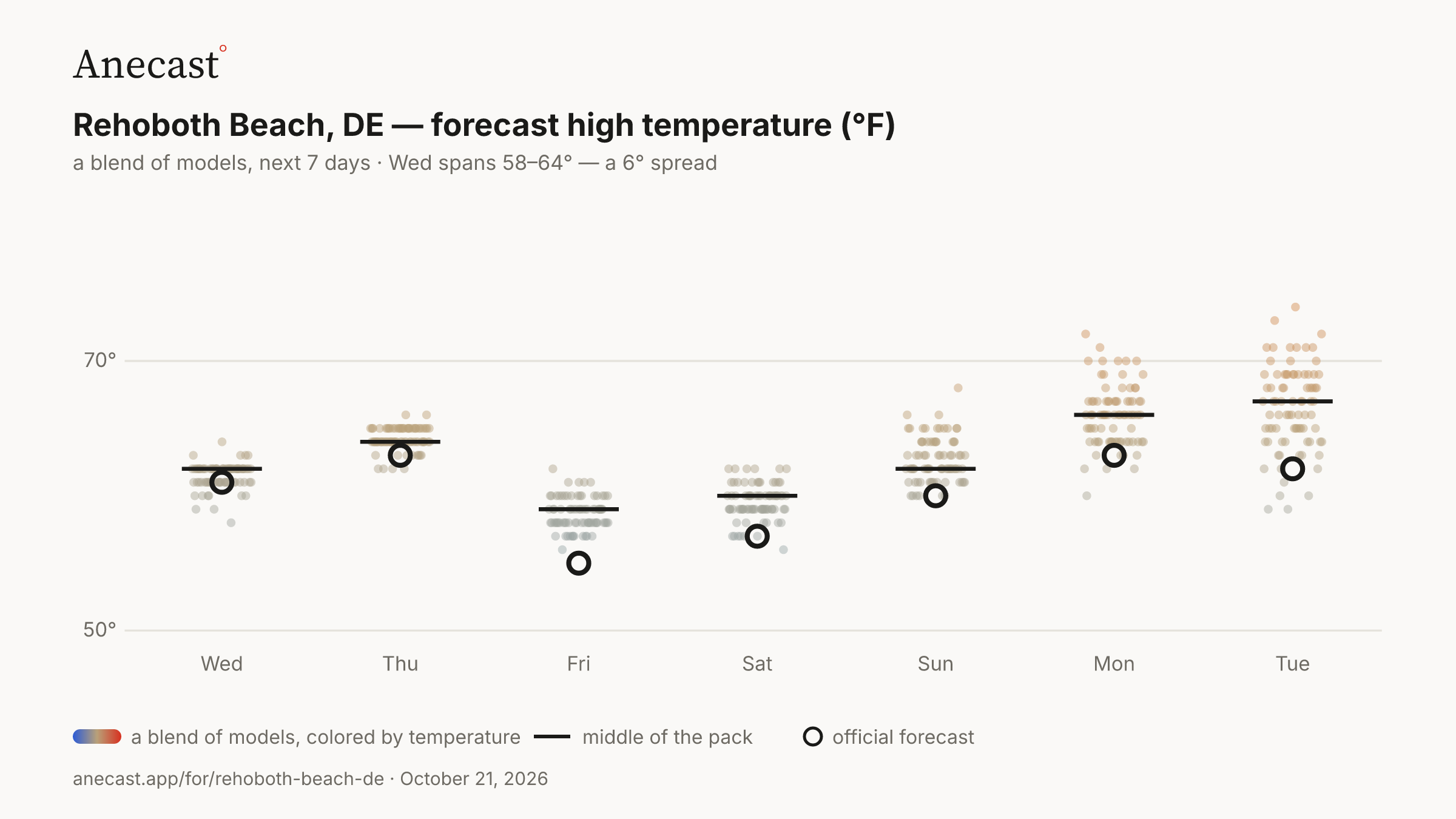
The models mostly agree this week. The widest day, Wed, spans 58–64°.

Forecast high temperature (°F) · next 7 days · a blend of models
PNG ↓
50°70°WedThuFriSatSunMonTue

82 model runs, colored by temperature  ·  middle of the pack  ·  NWS forecast

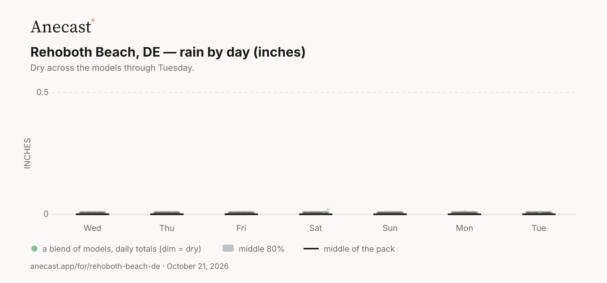
Dry across the models through Tuesday.

Rain by day (inches) · next 7 days · a blend of models
PNG ↓
0.50WedThuFriSatSunMonTueINCHES

82 model runs, daily totals (dim = dry)  ·  middle 80%  ·  middle of the pack

Also worth knowing

Thursday evening's tide could flood again, but lower

The nor'easter gets shoved out to sea Thursday by a system dropping in from the northwest, but Thursday evening's high tide could still bring spotty to widespread minor flooding, lower than tonight's. Thursday's forecast high is 64° under sun with a brisk north-northwest breeze.

coastal flood · tide

Tuesday ran warmer than most models expected

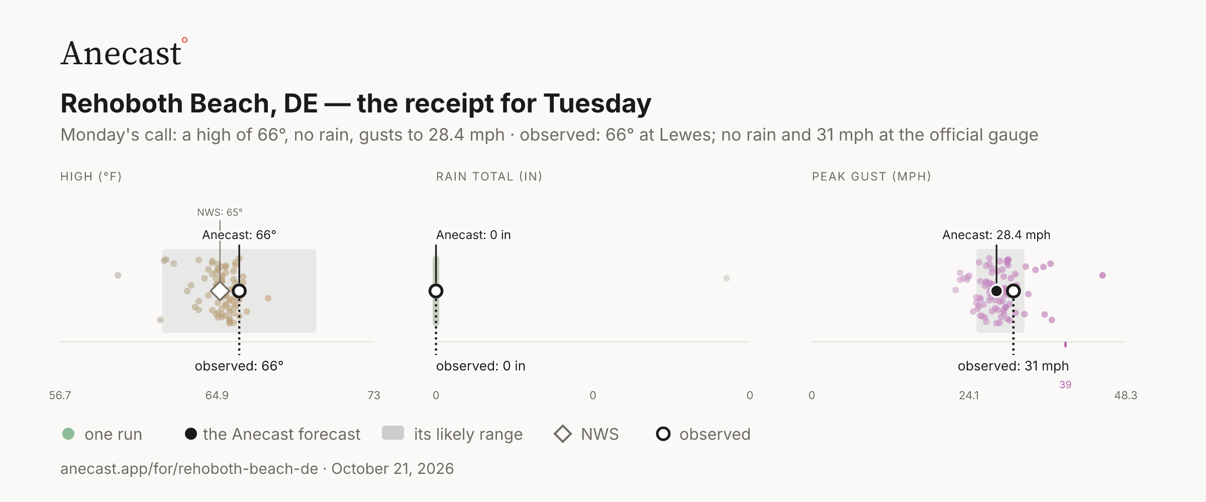
Lewes reached 66° Tuesday, warmer than 91% of Monday's weather models, which centered near 65°; the official gauge at Georgetown, inland, hit 69°. The peak gust of 31 mph also ran stronger than 85% of those models.

receipt · verification

Afternoon edition, 2026-10-21 · station history coming · tomorrow morning: what today's forecast said, next to what happened.

Yesterday's receipt · Tuesday

What Monday's forecast said for Tuesday · what was observed
PNG ↓
HIGH (°F)NWS: 65°Anecast: 66°observed: 66°56.764.973
RAIN TOTAL (IN)Anecast: 0 inobserved: 0 in000
PEAK GUST (MPH)39Anecast: 28.4 mphobserved: 31 mph024.148.3

Anecast forecast  ·  likely range  ·  dots = 82 runs, Monday  ·  ◇ NWS  ·  observed, Tuesday

Monday's call for Tuesday: a high of 66°, no rain, gusts to 28.4 mph. Observed: 66° at Lewes; no rain and 31 mph at the official gauge.

Around Rehoboth Beach · Tuesday

Lewes, 4.9 miles away and the station that grades Rehoboth Beach's forecast, read a high of 66°; the official gauge at Georgetown - Delaware Coastal hit 70°, 4° hotter.

WORCESTER Dover Rehoboth Beach HIGH (°F)66°70°official climate stationgrades the forecastLewes · grades the forecast · 4.9 mi · high 66° · low 58° · rain not reported 66°LewesGeorgetown - Delaware Coastal Airport · the official climate station · 15.6 mi · high 70° · low 46° · rain not reported 70°Georgetown - Delaware CoastalCape May · 18.2 mi · high 70° · low 52° · rain not reported 70°Cape MayBrandywine Shoal Light · 18.5 mi · high 66° · low 56° · rain not reported 66°Brandywine Shoal LightCape May County Airport · 22.2 mi · high 70° · low 48° · rain not reported 70°Cape MayOcean City, Ocean City Municipal Airport · 28.5 mi · high 66° · low 48° · rain not reported 66°Ocean CityLOW (°F)46°58°official climate stationgrades the forecastLewes · grades the forecast · 4.9 mi · high 66° · low 58° · rain not reported 58°LewesGeorgetown - Delaware Coastal Airport · the official climate station · 15.6 mi · high 70° · low 46° · rain not reported 46°Georgetown - Delaware CoastalCape May · 18.2 mi · high 70° · low 52° · rain not reported 52°Cape MayBrandywine Shoal Light · 18.5 mi · high 66° · low 56° · rain not reported 56°Brandywine Shoal LightCape May County Airport · 22.2 mi · high 70° · low 48° · rain not reported 48°Cape MayOcean City, Ocean City Municipal Airport · 28.5 mi · high 66° · low 48° · rain not reported 48°Ocean City
The stations
StationMilesHighUsual gapRain (at least)
Lewes · grades the forecast4.966°0°—
Georgetown - Delaware Coastal Airport · official gauge15.670°0°—
Cape May18.270°-3°—
Brandywine Shoal Light18.566°-3°—
Cape May County Airport22.270°0°—
Ocean City28.566°0°—

Observed at NOAA stations near the gauge: the National Weather Service's airports and mesonets, and on the coast NOAA's tide stations. A station's rain is "at least" what it reported. Rehoboth Beach's temperature forecast is graded at Lewes, the nearest station with a full day of readings; rain at the official gauge.

Keeping score

The scorecard · this week›

M
T
W
T
F
S
S

2 of 2 days on target

How each day was scored
ObservedAnecastNWS
forecastmissforecastmiss
Mon high 62° ✓ 61° −1° 60°−2°
rain 0.0 in ✓ 0.0 in in range 13%% only
Tue high 66° ✓ 66° 0° 65°−1°
rain 0.0 in ✓ 0.0 in in range 4%% only

Temperatures observed at Lewes, 4.9 miles from Rehoboth Beach; rain at the official gauge (GED), the nearest one. Every forecast is from the day before. A ✓ means the high landed inside the Anecast range, or the rain inside the models' band; gusts are shown but not graded.

Recent days

the last 4 days averaged -5° against normal · October so far: 2.24 inches of rain, 0.46 below normal · since Jan 1: 32.40 inches of rain, 3.41 below normal

Know when Rehoboth Beach's forecast changes

One email every morning: what changed overnight, what's unusual, and what yesterday's forecast got right or wrong. Free. Unsubscribe anytime.

Missing your city?

A request is how a place gets on the roster; the forecast tools already answer for anywhere in the US.